Wattle & Daub: Craft, Conservation & Wiltshire Case Study
Contents
Contents
2 History
3 Craft
3.3 Panel Types
3.4 Staves
3.6 Daub
3.7 Decoration
4.1 Soils
4.1.1 Constituents
4.1.2 Plasticity
4.1.3 Strength
4.1.4 Field Testing
4.1.5 Selection
4.2 Dung
4.2.2 Lignin
4.2.3 Urine
4.2.4 Microbial Debris
4.2.5 The Role of Dung
4.3 Fibre
5.2.3 Maintenance
5.3 Repair
5.3.1 Partial Renewal
5.4 Replacement
5.4.1 Brick Infill
5.4.2 Renewal
6.3 Fieldwork
6.5 Evaluation
| Title Page Previous Next | Wattle and Daub in Wiltshire >Documentary Evidence |
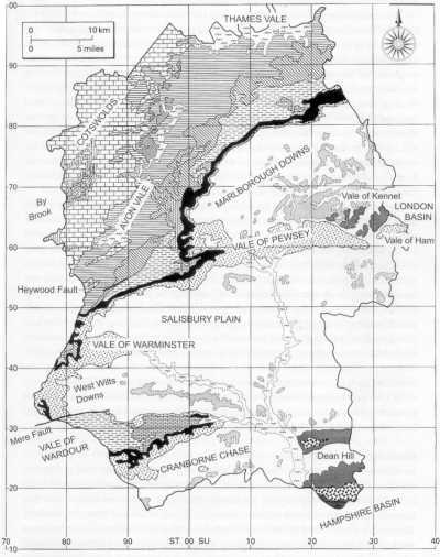
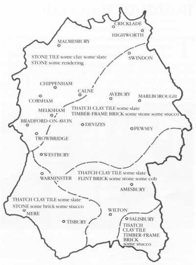
6.1 Documentary Evidence
Information on the history of building in Wiltshire is
increasingly comprehensive, with new material frequently published. A primary
source remains the Victoria County History of Wiltshire. Surveys, such as by the
Royal Commission on the Historical Monuments of England (RCHME) and books
focussing on specific towns or villages are also available. Other sources
investigated were the records of the archaeology department and museum objects
of Wiltshire County Council Library and Museum Services, Wiltshire
Archaeological and Natural History Society (together with their journal
Wiltshire Archaeological Magazine) and private archaeological businesses in the
county. Unfortunately, these all stop short of providing documentary evidence of
any detailed construction methods and so give little insight into the use of
wattle and daub beyond stating where it was used as infill.
However, the county is fortunate in having the Wiltshire Building Record (WBR), an archive invaluably organised by location, accompanied by three books by Pamela Slocombe published in association with The Record. These books provide an invaluable insight into the development and regional variation of Wiltshire’s buildings. Unfortunately, they do not provide specifics on wattle and daub, other than stating that during the 17th century a few buildings appear to have used decorative brick nogging as the original infill, often in a herringbone pattern.[125]
However, the county is fortunate in having the Wiltshire Building Record (WBR), an archive invaluably organised by location, accompanied by three books by Pamela Slocombe published in association with The Record. These books provide an invaluable insight into the development and regional variation of Wiltshire’s buildings. Unfortunately, they do not provide specifics on wattle and daub, other than stating that during the 17th century a few buildings appear to have used decorative brick nogging as the original infill, often in a herringbone pattern.[125]
A review of the WBR records were found to be limited with
respect to wattle and daub in that only a cursory mention is provided, if any.
However, the record was useful in identifying buildings that represented likely
candidates for the retention of the material and so formed a basis for
organising the fieldwork.
 |
 |
 |
 |
[125]
Slocombe (1988), p.9.